
A four-person team from the University of Alaska Fairbanks (UAF) is set to land an unmanned aircraft inside the crater of Costa Rica’s active Poás Volcano this week. The mission aims to sample gas emissions from the soil, providing crucial data for understanding the volcano’s subterranean activity. This effort is part of an international research collaboration focused on improving volcano monitoring and eruption forecasting.
Utilizing Drones for Volcanic Research
The UAF team will deploy two drones: one for scouting a landing site and the other to place scientific instruments for data collection. In addition to crater operations, researchers will collect soil gas samples from various locations around the volcano.
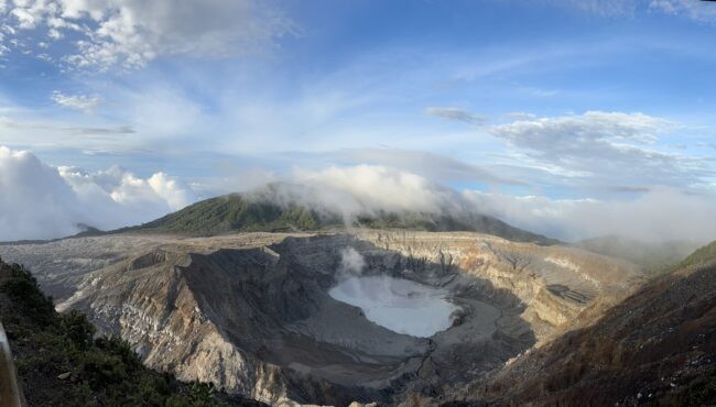
Poás Volcano, one of the most active and accessible volcanoes in Costa Rica, reaches an elevation of 8,848 feet above sea level and features a massive crater measuring 0.6 miles in diameter and about 1,000 feet deep. The crater can be observed via the OVSICORI (Volcanological and Seismological Observatory of Costa Rica) webcam.
The UAF Research Team
The UAF mission includes:
- Dr. Társilo Girona, research assistant professor at the Geophysical Institute
- Jason Williams, chief unmanned aircraft systems pilot at ACUASI (Alaska Center for Unmanned Aircraft Systems Integration)
- Matthew Westhoff, drone pilot
- James Copple, drone pilot
This NASA-funded project is science-driven but also serves as a proof-of-concept for using drones in Alaska’s 54 historically active volcanoes. If successful, this method will allow for safer and more efficient monitoring of soil gas emissions in highly active volcanic regions.
Research Objectives and Methodology
Dr. Girona will lead a nine-person international research team in analyzing:
- Carbon dioxide and water vapor emissions, indicators of magma and hydrothermal movement
- Soil temperature and moisture levels, which provide insight into underground heat activity
“One of the biggest challenges in volcanology is the inability to safely get close to volcanic activity,” said Dr. Girona. “If our drones succeed, we will demonstrate for the first time that soil degassing campaigns can be conducted remotely and much faster.”
Poás Volcano’s Recent Activity
Poás Volcano, located 25 miles northwest of San José within Poás Volcano National Park, has experienced frequent eruptions. Recent signs of heightened activity include:
- Increased seismic activity and sulfur dioxide emissions
- Ground uplift in the area
- A March 1, 2025, phreatic (steam-driven) eruption producing an ash column between 1,000 and 1,300 feet
- Subsequent smaller eruptions
“Phreatic explosions are unpredictable and can occur suddenly with little to no warning,” Girona explained. “Our goal is to improve forecasting by measuring soil degassing and environmental conditions.”
The Drone Deployment Strategy
This mission marks ACUASI’s first attempt to land a drone inside an active volcanic crater. The team will operate from a visitor platform one-third of a mile from the crater’s edge.
The procedure involves two drone types:
- Parrot (1-pound scout drone): Will identify a suitable landing site for the larger drone.
- Alta X Heavy Lift (24-pound drone): Will land, shut down its rotors while remaining powered, and deploy scientific instruments.
The Alta X carries a gas accumulation chamber, gas sensor, and soil sensor. It will press the chamber gently into the soil for about two minutes before taking off to a new location. The Parrot drone will hover nearby to confirm instrument placement and proper functionality.
“We’ll send the Parrot first to find a level spot,” said Williams. “We don’t want to risk landing the Alta X on a steep slope.”
The International Poás Volcano Study
This research is part of a larger, multi-year Poás community experiment, initiated during the Cities on Volcanoes 12th Congress in Guatemala. The project is backed by AVERT (Anticipating Volcanic Eruptions in Real-Time) in collaboration with OVSICORI.
Multiple research teams from different countries are using various scientific approaches to study Poás and refine eruption prediction techniques.
The Future of Drone-Assisted Volcanology
If successful, this project could revolutionize how volcanologists collect critical gas emission data while significantly reducing risks associated with fieldwork in hazardous environments. The innovative drone method being tested at Poás could be applied to volcanoes worldwide, including Alaska’s active volcanic systems.
As Poás continues to show signs of unrest, this mission represents an important step in leveraging technology to enhance volcanic hazard assessment and early warning capabilities.